The water level of La Mesa Dam is nearing spilling level amid the heavy rains brought about by Typhoon Carina and Habagat, state weather bureau PAGASA said Wednesday.
In an advisory, PAGASA said that as of 11:50 a.m. the water level of La Mesa Dam stood at 79.41 meters — near its spilling level of 80.15 meters.
“Water from La Mesa Dam is expected to affect the low-lying areas along the Tullahan River from Quezon City (Fairview, Forest Hills Subd., Quirino Highway, Sta. Quiteria, and San Bartolome), Valenzuela (Brgy. Ligon, North Expressway, La Huerta Subd.) and Malabon,” said PAGASA.
“All the residents living in the aforementioned areas, especially those near the river banks, are advised to be alert for possible flooding,” it added.
PAGASA said it will continue to monitor the hydrological condition of the dam to provide developments to concerned agencies and local governments.
Carina
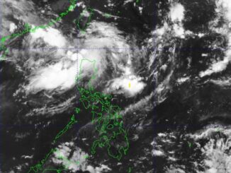
According to PAGASA, Batanes remains under storm signal number 2 as typhoon Carina continues to intensify while moving towards Taiwan.
Storm signal no. 1, meanwhile, was up over Babuyan Islands, northern portion of mainland Cagayan, and the northern portion of Ilocos Norte.
The center of the eye of the tropical cyclone was last seen 345 kilometers north northeast of Itbayat, Batanes. It is moving north northwestward at 15 kph while packing maximum sustained winds of 165 kph near the center, gustiness of up to 205 kph, and a central pressure of 940 hPa.—Sundy Locus/AOL, GMA Integrated News


Be the first to comment