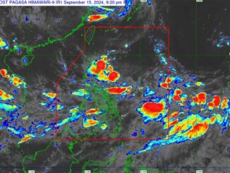
MANILA, Philippines — Another low-pressure area was spotted outside the Philippine area of responsibility (PAR), bringing to two the LPAs being monitored by the Philippine Atmospheric, Geophysical and Astronomical Services Administration.
PAGASA weather specialist Obet Badrina said the LPA outside PAR was located east of Luzon.
“Based on our latest satellite data, we have monitored two LPAs, one is inside PAR and the other is still outside PAR,” Badrina said.
He added that the LPA inside PAR was located 1,155 kilometers east-northeast of extreme Northern Luzon.
“As of now, we don’t expect the two LPAs to develop into typhoons, at least based on the latest data we have. The two LPAs have no direct effect in any parts of the country, but we will continue to monitor… We don’t discount the possibility that the LPAs would develop into typhoons,” Badrina added.
He said the southwest monsoon will continue to bring rains to the Visayas and the southern part of Luzon.
“Expect rains in Western Visayas, Negros Island region, Central Visayas, Southern Luzon and also Bataan and Zambales area,” Badrina said.
Meanwhile, the rest of Luzon, the rest of the Visayas and a big portion of Mindanao will experience isolated rainshowers and thunderstorms at night.
“It is possible that it rains at dawn, which is a characteristic of the southwest monsoon. Rain will persist in the Visayas and Southern Luzon in the next few days. There is also a big chance of rains in Occidental Mindoro, Zambales, Bataan,” he said.


Be the first to comment