


September 13, 2024 | 7:33pm
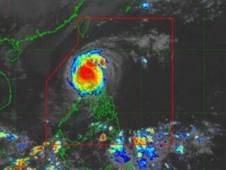
MANILA, Philippines — Tropical Storm Bebinca, with local name Ferdie, entered the Philippine area of responsibility (PAR) at 6 p.m. on Friday, September 13, according to the state weather bureau.
In its 11 a.m. bulletin, PAGASA reported that Bebinca already weakened, packing maximum sustained winds of 85 kilometer per hour near the center and gustiness of 105 kph.
The storm is expected to further weaken while it remains within PAR, the state bureau said.
However, meteorologists anticipate that Ferdie may intensify into a typhoon once reaches the East China Sea.
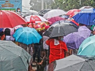
“Moderate to heavy rain showers with lightning and strong winds are expected over Bataan within the next 2 hours,” the state weather bureau said in a thunderstorm advisory issued at 6:51 p.m.
The locations likely to be affected by the same conditions are:
- Bulacan (Obando, Meycauayan, Marilao, Bulakan)
- Metro Manila (Valenzuela, Navotas, Malabon)
- Nueva Ecija (Cuyapo, Talugtug, Munoz, Lupao, Guimba, San Jose, Nampicuan)
- Tarlac (San Manuel, Anao, Ramos, Paniqui, Moncada, Camiling, San Clemente, Santa Ignacia)
- Zambales (Santa Cruz, San Antonio)
- Rizal (Morong, Baras, Tanay, Pililla)
- Laguna (Luisiana, Liliw, Nagcarlan, Rizal, San Pablo)
- Quezon (Dolores, Candelaria, Sariaya, Tayabas, Pagbilao, Tiaong, Lucena, Atimonan, Plaridel, Unisan, Pitogo, Macalelon, General Luna, Catanauan)
- Batangas (San Juan, San Pascual, Bauan, San Luis, Taal, Santa Teresita)
- Cavite(Imus, Kawit, General Trias, Tanza, Trece Martires)
Households are advised to prepare for potential hazards such as flash floods and landslides.
PAGASA is set to release Tropical Cyclone Bulletins at 11 p.m. on Friday to provide updates on the tropical storm’s track and intensity.

Be the first to comment