


September 2, 2024 | 4:11pm
MANILA, Philippines — Tropical Storm Enteng (international name: Yagi) made landfall in the vicinity of Aurora, state weather bureau PAGASA said.
In the state weather bureau’s 2 p.m.. tropical cyclone bulletin, “Enteng” was located over the coastal waters of Casiguran, Aurora traveling north northwestward at 20 kilometers per hour (kph) with sustained winds of 85 kph and gusts of 105 kph.
Enteng is anticipated to turn more northwestward over the landmass of mainland northern Luzon and emerge over the Luzon Strait by late morning of September 3.
PAGASA
According to PAGASA, Enteng may leave the Philippine area of responsibility on Wednesday, September 4.
But during its traverse of mainland Luzon, Enteng is expected maintain the strength of cyclones under the tropical storm category, which is between 62 to 88 kph.
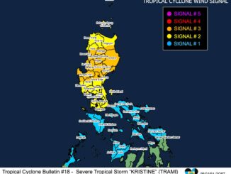
Wind signals
The tropical cyclone wind signals in areas over Luzon are still in effect.
Here are the Tropical Cyclone Wind Signals hoisted as of 2 p.m.:
Signal No. 2
- Ilocos Norte
- Apayao
- Eastern portion of Kalinga (Rizal, Pinukpuk, City of Tabuk)
- Cagayan, including Babuyan Islands
- Isabela
- Quirino
- Northern portion of Aurora (Casiguran, Dilasag, Dinalungan, Dipaculao, Baler)
- Polillo Islands
- Northern portion of Camarines Norte (Santa Elena, Capalonga, Jose Panganiban, Paracale, Vinzons)
Winds in these areas are expected to range from 62 to 88 kph, posing a minor to moderate threat to life and property.
Signal No. 1
- Batanes
- Rest of Ilocos Norte
- Ilocos Sur
- La Union
- Eastern portion of Pangasinan (Rosales, Asingan, Binalonan, Sison, San Manuel, Santa Maria, Balungao, San Quintin, Tayug, Umingan, Natividad, San Nicolas)
- Abra
- Rest of Kalinga
- Mountain Province
- Ifugao
- Benguet
- Nueva Vizcaya
- Rest of Aurora
- Nueva Ecija
- Eastern portion of Pampanga (Candaba)
- Eastern portion of Bulacan (Doña Remedios Trinidad, Norzagaray, City of San Jose del Monte, Obando, City of Meycauayan, Bocaue, Balagtas, Bustos, Baliuag, Pandi, Santa Maria, Marilao, Angat, San Rafael, San Ildefonso, San Miguel)
- Metro Manila
- Rest of Quezon
- Rizal
- Laguna
- Eastern portion of Batangas (San Juan, Santo Tomas, City of Tanauan, Lipa City, Malvar, Balete, Padre Garcia, Rosario)
- Marinduque
- Rest of Camarines Norte
- Camarines Sur
- Catanduanes
- Albay
Winds in these areas are forecast to be between 39 and 61 kph, with minimal to minor impacts expected.


Be the first to comment