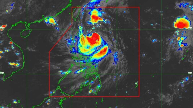
(UPDATES) THE state weather bureau on Saturday upgraded “Julian” (international name: Krathon) from a tropical depression to a tropical storm and said it could intensify to a typhoon by Monday.
As of 5 p.m. on Saturday, the weather bureau said Julian was 380 kilometers east of Aparri, Cagayan, with maximum sustained winds of 65 km per hour (kph) near the center and with gustiness of up to 90 kph and moving west-northwestward at 15 kph, as well a central pressure of 996 hectopascals. It was moving west-northwestward at 15 kph.
Julian also has strong to gale-force winds extending outwards up to 420 km from the center.
In the same bulletin, the Philippine Atmospheric, Geophysical and Astronomical Services Administration (Pagasa) put the following areas under storm signal No. 1: Batanes, Cagayan, including Babuyan Islands, Isabela, Apayao, Kalinga, the eastern portion of Mountain Province (Natonin, Paracelis), the eastern portion of Ifugao (Aguinaldo, Alfonso Lista), Ilocos Norte, and the northern portion of Aurora (Dilasag, Casiguran).
“Julian is forecast to move west-southwestward or westward [on Saturday], then generally northwestward [on September 29] through Monday (September 30) towards the Batanes-Babuyan Islands area, before accelerating north-northeastward over the waters east of Taiwan on Tuesday (October 1) onwards,” the weather bureau said in its bulletins.
In its 4 p.m. weather forecast, Pagasa said Batanes, Cagayan, including Babuyan Islands, Isabela, Apayao, and Ilocos Norte were forecast to have rains with gusty winds, while Central Luzon, Quezon, Camarines Norte, Camarines Sur, Catanduanes, and the rest of Ilocos Region, Cordillera Administrative Region, and Cagayan Valley would have cloudy skies with scattered rains and thunderstorms.Metro Manila and the rest of the country, meanwhile, would have partly cloudy to cloudy skies with localized thunderstorms and isolated rain showers.
It is expected that from a severe tropical storm, Julian will become a typhoon on Monday and could even become a super typhoon, Pagasa said.
“Julian will continue to intensify throughout the forecast period and reach typhoon category on Monday. There is a high chance of rapid intensification, and the possibility of reaching the super typhoon category is not ruled out. This tropical cyclone will be closest to Batanes and/or Babuyan Islands at or near peak intensity,” the weather bureau said.
Meanwhile, Pagasa is also monitoring another tropical storm named “Jebi,” which is 2,180 km east of Extreme Northern Luzon and is 75 kph near the center, with gusts of up to 90 kph and is moving north northwest at 20 kph.


Be the first to comment