


MANILA, Philippines — Metro Manila and nearby provinces will continue to experience rains on Tuesday due to an enhanced southwest monsoon even after the Philippine Atmospheric Geophysical Astronomical Services Administration (Pagasa) lifted Signal No. 1 over the affected areas as Tropical Storm, “Enteng” moved over the West Philippine Sea.
But Signal No. 2 remains up over Ilocos Norte, the northern portion of Ilocos Sur (Sinait, Cabugao, San Juan, Magsingal, Santo Domingo, San Ildefonso, San Vicente, Santa Catalina, City of Vigan, Bantay, Santa and Caoayan), Apayao, Abra, Kalinga, and the western portion of Mainland Cagayan (Piat, Santo Nino, Camalaniugan, Tuao, Pamplona, Alcala, Amulung, Buguey, Solana, Rizal, Claveria, Iguig, Lasam, Aparri, Ballesteros, Abulug, Allacapan, Sanchez-Mira and Santa Praxedes) including Babuyan Islands (Calayan Is., Dalupiri Is. and Fuga Is.).
Signal No. 1 is raised over the rest of Ilocos Sur, the northern portion of La Union (Luna, Santol, San Juan, Bagulin, Bangar, San Gabriel, Bacnotan, Sudipen and Balaoan), Mountain Province, Ifugao, the northern portion of Benguet (Mankayan, Kapangan, Atok, Kabayan, Kibungan, Bakun, Buguias and Tublay), Batanes, the rest of Mainland Cagayan, the rest of Babuyan Islands, Isabela, the northern portion of Nueva Vizcaya (Bayombong, Ambaguio, Bagabag, Villaverde, Diadi, Quezon and Solano), and the northern portion of Quirino (Aglipay, Saguday, Diffun and Cabarroguis), also in Luzon.
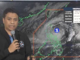
Pagasa said in its 5 a.m. bulletin that the center of the eye of the tropical storm was over the coastal waters of Paoay, Ilocos Norte.
Packing maximum sustained winds of 75 kilometers per hour (kph) near the center and gustiness of up to 125kph, Enteng is moving north-westward at 25kph, the weather agency said.
Pagasa Administrator Nathaniel Servando told The Manila Times that the National Capital Region and other neighboring provinces were no longer affected by the tropical storm.
“It’s the enhanced southwest monsoon locally known as ‘habagat’ that is bringing occasional rains,” Servando said.
Citing Pagasa’s data and analysis, he said Enteng would continue moving generally west-northwestward over the next 24 hours and is expected to turn westward over the West Philippine Sea.
“On the track forecast, this tropical cyclone may exit the Philippine Area of Responsibility by tomorrow (Wednesday) morning,” the Pagasa chief said.
He added that Enteng would likely reach severe tropical storm category anytime of the day and become a typhoon by Thursday.


Be the first to comment