


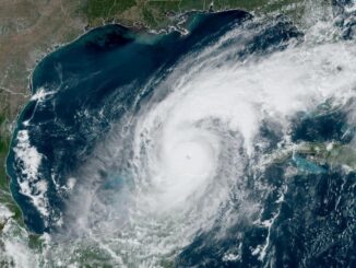
Driving rain flooded roadways and closed down airports in Florida as an intensifying Hurricane Helene marched toward the state’s Panhandle region, bringing the threat of a potentially deadly storm surge to much of the coastline.
The storm had strengthened into a Category 2 hurricane early on Thursday and had maximum sustained winds of 105 mph (169 kph) as of 11 a.m. (1500 GMT), according to Michael Brennan, the director of the National Hurricane Center.
Helene was forecast to continue gaining power on its northward path toward Florida’s Big Bend region, where it was expected to make landfall in the evening, possibly as a Category 4 storm with sustained winds in excess of 130 mph (209 kph).
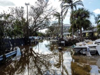
Officials pleaded with residents in the path of the storm to heed mandatory evacuation orders or face life-threatening conditions. Helene’s surge – the wall of seawater pushed on land by hurricane-force winds – could rise to as much as 20 feet (6.1 meters) in some spots, as tall as a two-story house.
“A really unsurvivable scenario is going to play out” in the coastal area, Brennan said, with water capable of destroying buildings and carrying cars pushing inland.
The hurricane was about 255 miles southwest of Tampa as of 11 a.m. ET, but tropical storm force winds were extending 350 miles out from its center and were already affecting the Florida Keys and southwest Florida, Brennan said.
Strong rain bands were whipping parts of coastal Florida, and rainfall has already lashed Georgia, South Carolina, central and western North Carolina and portions of Tennessee. Atlanta, hundreds of miles north of Florida’s Big Bend, was under a tropical storm warning.
In Pinellas County, which sits on a peninsula surrounded by Tampa Bay and the Gulf of Mexico, roads were already filling with water before noon. Officials warned the storm’s impact could be as severe as last year’s Hurricane Idalia, which flooded 1,500 homes in the low-lying coastal county.
Videos posted on the county’s social media site showed some swamped beachside roads and water rising over boat docks.
Airports in Tampa, Tallahassee and St. Petersburg all suspended operations on Thursday.
Governor Ron DeSantis warned north Florida residents to flee before time runs out.
“You have time to get to a shelter, but you’ve got to do it now,” he said at a morning news briefing. “Every minute that goes by brings us closer to having conditions that are going to be simply too dangerous to navigate.”
Helene is expected to still be a full-fledged hurricane as it rolls through the Macon, Georgia, area on Friday, forecasters said. It could bring 12 inches of rain or more, potentially devastating the state’s cotton and pecan crops, which are in the middle of harvesting season.
“The current forecast for hurricane Helene suggests this storm will impact every part of our state,” Georgia Governor Brian Kemp said.
After making landfall across the Florida coast, Helene is expected move more slowly over the Tennessee Valley on Friday and Saturday, the NHC said.
Wall of water
Storm surge was forecast to reach 15 to 20 feet (4.6 to 6.1 meters) in the Big Bend area of Florida’s Panhandle region where the storm is expected to come ashore.
Numerous evacuations were ordered along Florida’s Gulf Coast, including Sarasota and Charlotte counties.
Pinellas County officials ordered evacuations of long-term healthcare facilities near the coast, including nursing homes, assisted living centers and hospitals.
Not everyone heeded the evacuation orders. In coastal Dunedin, Florida, about 25 miles west of Tampa, state ferry boat operator Ken Wood, 58, planned to ride out the storm with his 16-year-old cat, Andy.
“We’re under orders, but I’m going to stay right here at the house,” Wood told Reuters by telephone. “The storm looks like it’ll be a bit west of us, but who knows? I’m sure it’ll be interesting to say the least.”
John Dailey, the mayor of Tallahassee, Florida’s capital city that is in the direct path of Helene, said the hurricane could be the strongest storm to ever make a direct hit on his city.
Helene could produce “unprecedented damage like nothing we have ever experienced before as a community,” Dailey told reporters on Wednesday.
Reinsurance broker Gallagher Re said preliminary private insurance losses could reach $3 billion to $6 billion, with additional losses to federal insurance programs approaching a potential $1 billion.
Energy facilities along the U.S. Gulf Coast scaled back operations and evacuated some production sites.
The director of the Federal Emergency Management Agency, Deanne Criswell, said at a White House briefing that she would travel to Florida on Friday to assess the damage.
Helene was expected to dump up to 15 inches (38.1 cm) of rain in some isolated spots after making landfall in Florida, causing considerable flash and urban flooding, the hurricane center said.
National Hurricane Center Deputy Director Jamie Rhome said about half of lives lost in hurricanes typically came from flash flooding caused by torrential rain, often among people who drive into flooded roads and are swept away. He urged those in affected areas to use extreme caution.
Rhome added that the expected hurricane-force wind impact area stretched around 180 miles (290 km) north from the Florida panhandle to southern Georgia.
“You need to prepare for prolonged (energy) outages. Those trees are going to come down in strong winds, block roads,” Rhome said. — Reuters

Be the first to comment