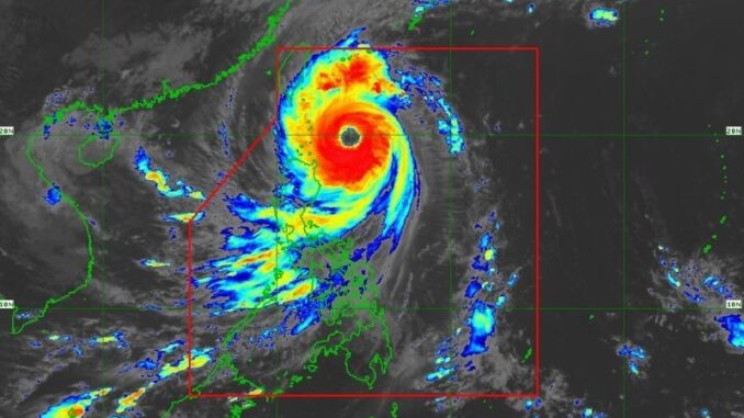
MANILA, Philippines — State weather bureau PAGASA has raised Signal No. 4 over Batanes as Super Typhoon Leon approaches the province on Wednesday, October 30.
As of 2 p.m., Leon’s eye was located 310 kilometers east of Calayan, Cagayan, moving northwestward at 15 kilometers per hour (kph).
Leon currently sustains peak winds of 185 kph near its center, with gusts reaching up to 230 kph.
As it nears Batanes, PAGASA said it remains possible for the super typhoon to make landfall in the province.
Wind signals
PAGASA placed the following areas under tropical cyclone wind signals:
Signal No. 4, typhoon-force winds (18 kph to 184 kph)
Signal No. 3, storm-face winds (89 kph to 117 kph)
- eastern portion of Babuyan Islands (Babuyan Island, Camiguin Island, Calayan Island)
- northeastern portion of mainland Cagayan (Santa Ana)
Signal No. 2, gale-force winds (62 kph to 88 kph)
- The rest of Babuyan Islands
- rest of mainland Cagayan
- northern and eastern portions of Isabela (Santo Tomas, Santa Maria, Quezon, San Mariano, Naguilian, Dinapigue, Delfin Albano, San Pablo, Ilagan City, Benito Soliven, Tumauini, Cabagan, Palanan, Quirino, Divilacan, Gamu, Mallig, Maconacon, Burgos, City of Cauayan, San Guillermo, Angadanan, Cabatuan, Luna, Reina Mercedes, Roxas, Aurora, San Manuel)
- Apayao
- Kalinga
- northern and eastern portions of Abra (Tineg, Lacub, Malibcong, Lagayan, San Juan, Lagangilang, Licuan-Baay, Daguioman)
- eastern portion of Mountain Province (Paracelis)
- Ilocos Norte
Signal No. 1, strong winds (39 kph to 61 kph)
- rest of Isabela
- Quirino
- Nueva Vizcaya
- rest of Mountain Province
- Ifugao
- Benguet
- rest of Abra
- Ilocos Sur
- La Union
- Pangasinan
- Nueva Ecija
- Aurora
- northeastern portion of Tarlac (Camiling, San Clemente, Paniqui, Moncada, Anao, San Manuel, Pura, Ramos, Victoria, Gerona, Santa Ignacia, City of Tarlac, La Paz)
- northern portion of Bulacan (Doña Remedios Trinidad, San Miguel)
- northern portion of Quezon (Infanta, General Nakar) including Polillo Islands
- Camarines Norte
- northern portion of Camarines Sur (Siruma, Tinambac, Lagonoy, Garchitorena, Caramoan)
- northern and eastern portions of Catanduanes (Pandan, Gigmoto, Bagamanoc, Panganiban, Viga, Baras, Caramoran)
The state weather bureau said that although no wind signal was raised for the following areas, they still experienced “gusty conditions” on Wednesday:
- Bataan
- Metro Manila
- Calabarzon
- Mimaropa
- Bicol Region
- Most of Visayas
- Dinagat Islands
Storm surge. Coastal flooding is also likely within the next 48 hours as storm surges could exceed 3.0 meters above normal tide levels, putting coastal areas in Batanes and Babuyan Islands at risk, PAGASA said.
Forecast track
PAGASA
Super Typhoon Leon is expected to cross the Philippine Sea before it makes landfall in Taiwan by Thursday, October 31.
PAGASA anticipates Leon to exit the Philippine area of responsibility (PAR) by Thursday evening or early morning of Friday, November 1.


Be the first to comment