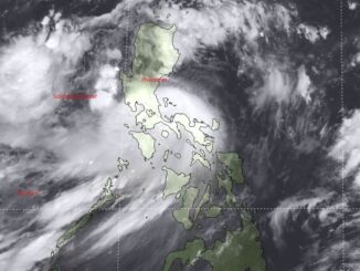
Several infrastructure were damaged by a storm surge in Sta. Ana, Cagayan due to Typhoon Leon, according to Jonathan Andal’s report in 24 Oras on Thursday.
State weather bureau PAGASA defines storm surges as the abnormal rise of sea level during tropical cyclones or typhoons.
Sea water severely damaged a house in Sta. Ana, leaving only its roof intact. High waves also engulfed the land where it stood, causing it to collapse.
“Naawa ako sa anak ko. Siya ang nagpagawa ng bahay namin. Ang tulong sana ay yung pag-lipatan namin,” said resident Josefina Tangonan.
(I feel bad because it was my child who built our house. We are hoping to find a new home.)
But the municipal government said the area where Tangonan’s house was located is actually a “no build zone” since it is 40 meters away from the high tide level of the sea.
“Paalis na natin ‘yan. Yung bahay nila too much na sa dagat talaga. Actually wala kaming in-issue na zoning permits sa mga ‘yan,” said Mayor Nelson Robinion.
(We have to get them away from there. Their houses are too near the sea. We did not actually issue zoning permits to them.)
The damaged seawalls constructed by residents were also not approved by the local government.
Robinion said that they will provide assistance to residents affected by the storm surge, but they will still be reported to the Department of Environment and Natural Resources.
Meanwhile, a damaged resort noted that it is within a so-called “salvation zone”, the report said.
The resort management added that their facilities were far from the sea when they opened in 2019. But said the land has receded over the years.
With this, residents are also worried that the sea seems to be getting closer to the coastal communities, citing climate change as a reason.
“There was a study presented to us that by 2030, yung shorelines natin aakyat siya. Tapos yung usable land area natin mababawasan. Unti-unti, lumalapit yung shoreline natin sa mga residences…attributed to climate change,” Ruelie Rapsing, Cagayan Provincial Disaster Risk Reduction and Management Office chief.
(There was a study presented to us that by 2030, our shorelines will move further. So the usable land areas will become smaller. Our shorelines will slowly get closer to our residences and we can attribute that to climate change.)
Sta. Ana and other areas in the northern portion of Cagayan are under Signal No. 1, according to PAGASA’s 5 p.m. bulletin. —Vince Angelo Ferreras/RF, GMA Integrated News


Be the first to comment