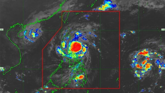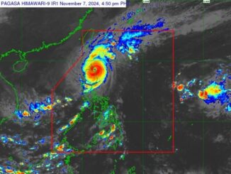
MANILA, Philippines — Severe Tropical Storm Nika has further intensified to near-typhoon category, the Philippine Atmospheric, Geophysical and Astronomical Services Administration (PAGASA) said yesterday.
“Severe Tropical (Storm) Nika is expected to make landfall either in Isabela or Aurora, (Monday) morning or early afternoon. As Nika is expected to reach typhoon category, it is possible that the highest wind signal is No. 4,” PAGASA weather specialist Veronica Torres said.
As of 5 p.m. yesterday, the center of Nika was located 380 kilometers east of Infanta, Quezon with maximum sustained winds of 110 km per hour near the center and gustiness of up to 135 kph as it moves westward at 20 kph.
Nika was forecast to reach typhoon category yesterday and may reach its peak intensity of around 130 kph prior to landfall, according to PAGASA.
Torres said Nika intensified into a severe storm category at 5 a.m. yesterday.
“If we will compare it to Typhoon Leon, although the two cyclones both reach typhoon category, Leon was stronger, as it was in the upper intensity of typhoon category as it reached 175 kph. The peak of Nika is expected to reach 130 kph,” Torres said.
She added that, aside from Aurora and Isabela, areas in Central and Northern Luzon will be affected by the rainbands of Nika.
“The public should remain on alert, especially those living in Northern and Central Luzon areas, including the northern portion of Southern Luzon,” she added.
Torres said tropical cyclone wind signal No. 2 was hoisted in the northern portion of Aurora, including Dilasag, Casiguran, Dinalungan, Dipaculao, Maria Aurora and Baler; Isabela, Quirino, the southern portion of mainland Cagayan, including Solana, Iguig, Peñablanca, Tuguegarao City, Enrile, Baggao, Alcala, Amulung, Santo Niño, Rizal, Piat, Tuao, Gattaran and Lasam; Nueva Vizcaya, the southern portion of Apayao, including Kabugao, Conner, Flora and Pudtol; Abra, Kalinga, Mountain Province, Ifugao, Benguet, the northern portion of Nueva Ecija, including Carranglan, Pantabangan, Lupao and San Jose City; and the southern portion of Ilocos Sur, including Narvacan, Nagbukel, Cervantes, Quirino, San Emilio, Santa Maria, Burgos, San Esteban, Santiago, Lidlidda, Banayoyo, Candon City, Galimuyod, Salcedo, Gregorio del Pilar, Sigay, Santa Lucia, Santa Cruz, Suyo, Alilem, Tagudin and Sugpon; La Union and the northeastern portion of Pangasinan, including San Nicolas, Natividad, San Quintin, Sison, San Manuel, Umingan and Tayug.
Tropical cyclone wind signal No. 1 was raised in Metro Manila; the rest of Cagayan including Babuyan Islands; the rest of Apayao, Ilocos Norte; the rest of Ilocos Sur; the rest of Pangasinan; the rest of Aurora, Tarlac; the northern and central portions of Zambales, including Santa Cruz, Candelaria, Masinloc, Palauig, Iba, Botolan, Cabangan, San Marcelino, San Felipe and San Narciso; the rest of Nueva Ecija, Pampanga, Bulacan, Rizal, the eastern portion of Laguna, including Santa Maria, Mabitac, Pakil, Pangil, Famy, Siniloan, Paete, Kalayaan, Cavinti, Lumban, Luisiana, Santa Cruz, Magdalena, Pagsanjan, Majayjay, Liliw, Nagcarlan, Pila and Victoria.
Other areas under tropical cyclone signal No. 1 include the eastern portion of Quezon, including Calauag, Guinayangan, Tagkawayan, Pitogo, San Andres, Buenavista, San Francisco, Pagbilao, Infanta, Lopez, Catanauan, Mulanay, Unisan, General Luna, Plaridel, Quezon, Alabat, Sampaloc, Padre Burgos, Macalelon, Mauban, Perez, Agdangan, Gumaca, Atimonan, Real, San Narciso, General Nakar, Lucban, Tayabas City and Lucena City, including Polillo Islands, Camarines Norte, Camarines Sur, Catanduanes and the northeastern portion of Albay, including Malinao, Tiwi, Bacacay, Tabaco City, Malilipot and Rapu-Rapu.
Torres said that for today, moderate to heavy rainfall or from 50 to 100 millimeters (mm) of rains is expected in Aurora, Quezon, Catanduanes, Camarines Norte, Camarines Sur and Northern Samar.
She added that intense to torrential rains or up to 200 mm is expected tomorrow in Cagayan, Isabela, Apayao and Aurora; heavy to intense or 100 to 200 mm in Kalinga, Mountain Province, Quirino, Nueva Vizcaya, Ifugao and Abra; moderate to heavy or 50 to 100 mm of rainfall is expected in Catanduanes, Camarines Norte, Camarines Sur, Quezon, Nueva Ecija, Benguet, Ilocos Norte and Ilocos Sur.
Torres said that from noon tomorrow until Wednesday noon, heavy to intense or from 100 to 200 mm of rainfall is expected in Kalinga, Apayao, Abra, Mountain Province, Ifugao, Ilocos Norte and Ilocos Sur; moderate to heavy or 50 to 100 mm of rainfall in Pangasinan, La Union, Benguet, Nueva Ecija, Nueva Vizcaya, Quirino, Cagayan, Isabela and Aurora.
“Forecast rainfall may be higher in mountainous and elevated areas. Moreover, impacts in some areas may be worsened by significant antecedent rainfall,” PAGASA said.
The state weather bureau added a moderate to high risk of storm surge may occur in the next 48 hours in the low-lying or exposed coastal localities of Ilocos Norte, Ilocos Sur, La Union, Pangasinan, Cagayan including Babuyan Islands, Isabela, Zambales, Aurora, Quezon including Polillo Islands, Camarines Norte, Camarines Sur and Catanduanes.
PAGASA issued a gale warning over the eastern seaboard of Luzon, as up to seven-meter high waves may occur in Isabela and northern Aurora; up to 5.5-meter high waves in the remaining seaboard of Aurora, the northern and eastern seaboards of Polillo Islands; the seaboard of Camarines Norte; and up to 4.5-meter high waves at the eastern seaboard of mainland Cagayan; the northern seaboards of Camarines Sur and Catanduanes; the western seaboard of Ilocos Norte and the seaboard of Ilocos Sur.
“Sea travel is risky for all types or tonnage of vessels. All mariners must remain in port or, if underway, seek shelter or safe harbor as soon as possible until winds and waves subside,” PAGASA said.
PAGASA said that Nika is expected to traverse the landmass of mainland Northern Luzon and emerge over the West Philippine Sea this evening.
Torres said Nika is expected to leave the Philippine area of responsibility (PAR) by tomorrow afternoon or evening.
LPA outside PAR to intensify
Torres said that aside from Nika, another cyclone is expected to enter the country, as the low-pressure area (LPA) outside PAR is expected to intensify into a tropical depression before it enters the country in the next 24 hours.
“Unfortunately, we expect that LPA outside PAR to intensify into a typhoon, and enter PAR within the next 24 hours,” she said.
The LPA was located 2,020 km east of Eastern Visayas.
Preparing for Nika Defense Secretary Gilberto Teodoro Jr., chair of the National Disaster Risk Reduction and Management Council, instructed regional directors to enact emergency preparedness actions during a meeting yesterday with key government officials at Camp Aguinaldo
Defense Assistant Secretary Bernardo Rafaelito Alejandro IV urged regional directors to activate their local regional inter-agency coordinating cells to ensure effective communication.
Office of Civil Defense Director Agnes Palacio said affected regions should leverage available data and resources for preparedness planning.
Mandatory evacuation
Interior Secretary Jonvic Remulla yesterday ordered the mandatory evacuation of residents in at least 2,500 barangays threatened by landslides and flooding brought by Nika.
“With the rains brought by the previous typhoons – Kristine, Marce and Leon – the soil is already saturated and the possibility of landslide is high. I already issued an advisory to all the concerned governors and mayors, all the 2,500 barangays affected and identified by the Department of Environment and Natural Resources that potential landslides are high, the mandatory evacuation will start (Sunday night),” Remulla said.
He added that concerned local government units have 16 hours to ensure that their constituents are evacuated.
“We are prepared on the ground as far as national agency responders are concerned, but it is a matter of cooperation in Regions 1, 2 and the Cordillera Administrative Region,” Remulla said.
“That (mandatory evacuation) is the most difficult job of barangay captains. Everybody should be convinced to join. That (refusal to leave their homes) is the mentality of Filipinos. I was a governor for a very long time. There were members of the family who chose to stay to look after their homes,” he said.
Remulla gave assurance that authorities will do everything to make sure no one is left behind during the mandatory evacuation.
“We have a one-day window on Wednesday if we need to replenish (our relief goods). Our C-130, land vehicles, helicopters (can) deliver more relief goods. Our air assets of the Air Force and the Philippine National Police are also prepared for air rescue in isolated barangays,” he said.
People stranded at ports, flight cancellations
As of 4 p.m. yesterday, the Philippine Coast Guard (PCG) monitored 369 passengers, truck drivers and cargo helpers stranded at seven seaports in its Southern Tagalog and Bicol Districts.
Also stranded were 63 rolling cargoes, two ships and four motorized boats. One vessel decided to take shelter, as protection against bad weather conditions caused by Nika.
As of 11 p.m. on Saturday, the PCG District Southern Tagalog had already temporarily suspended all vessels and watercraft from plying the route within the area of responsibility of Northern Quezon and Southern Quezon.
As for the PCG District Northwestern Luzon, under commander Captain Mark Larsen Mariano, it had already prepositioned all of its Deployable Response Groups and equipment in preparation for the effects of Nika.
Laoag International Airport announced yesterday the cancellation of Philippine Airlines flights PR 2196/2197 Manila-Laoag-Manila.
Prayers for protection
Still recovering from the effects of Severe Tropical Storm Kristine last month, Virac, Catanduanes Bishop Luisito Occiano, in an interview over Radio Veritas, requested for prayers to spare the province from harm caused by Nika.
“I again humbly ask each of you to join together in fervent prayer, seeking the intercession of Our Blessed Mother to protect us against this storm. Together, let us implore the Lord to shield us from harm and grant safety to all those in the path of this storm,” Occiano said. — Rudy Santos, Evelyn Macairan, Pia Lee-Brago


Be the first to comment