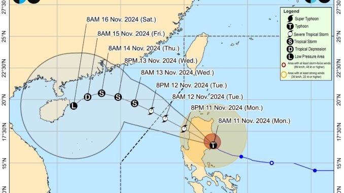
Severe Tropical Storm ‘Nika’ (international name: Toraji) has made landfall over Disalag, Aurora and is now traversing Northern Luzon, the state weather bureau said on Monday.
According to the latest 11 AM advisory from the Philippine Atmospheric, Geophysical and Astronomical Services Administration (PAGASA), Typhoon ‘Nika’ is moving northwestward at 25 kilometers per hour with maximum sustained winds of 130 kilometers per hour near the center and gustiness of up to 160 kilometers per hour.
Its center was last estimated in the vicinity of San Agustin, Isabela.
Tropical Cyclone Wind Signal (TCWS) No. 4 is raised over the northernmost portion of Aurora, the central and southern portions of Isabela, Kalinga, Mountain Province, the northern portion of Ifugao, the central and southern portion of Abra, and the northern and central portions of Ilocos Sur.
Meanwhile, TCWS No. 3 is hoisted over the central portion of Aurora, the northern portion of Quirino, the northeastern portion of Nueva Vizcaya, the rest of Isabela, the southwestern portion of Cagayan, the southern portion of Apayao, the rest of Abra, the rest of Ifugao, the northern portion of Benguet, the southern portion of Ilocos Norte, and the rest of Ilocos Sur.
TCWS No. 2 is assigned to the northwestern and eastern portions of Cagayan, the rest of Nueva Vizcaya, the rest of Quirino, the rest of Apayao, the rest of Benguet, the rest of Ilocos Norte, La Union, the northeastern portion of Pangasinan, the central portion of Aurora, and the northern portion of Nueva Ecija.
Finally, TCWS No.1 is raised over Babuyan Islands, the rest of mainland Cagayan, the rest of Pangasinan, the rest of Aurora, the rest of Nueva Ecija, Bulacan, Pampanga, Tarlac, the northern and central portions of Zambales, Metro Manila, Rizal, the eastern portion of Laguna, the northern and eastern portions of Quezon including Polillo Islands.
The weather disturbance will traverse the landmass of mainland Luzon today and emerge over the sea west of Ilocos Sur this afternoon or evening. Regardless of the position of the center in the next several hours, hazards on land and coastal waters may still be experienced in areas outside the forecast confidence cone.
“This tropical cyclone may weaken into a severe tropical storm while traversing mainland Luzon due to land interaction. A generally weakening trend may then be expected for this tropical cyclone until it becomes a remnant low over the sea near southern China,” said PAGASA.
‘Nika’ will move west northwestward over the West Philippine Sea and exit the Philippine Area of Responsibility by Tuesday morning or afternoon. It is forecast to continue to move generally west northwestward until Thursday before turning generally southwestward on Friday onwards.


Be the first to comment