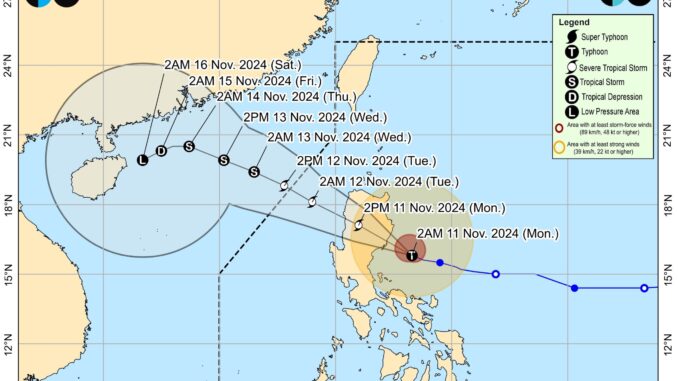
Severe Tropical Storm ‘Nika’ (international name: Toraji) intensified into a typhoon over the sea east of Aurora, the state weather bureau said on Monday.
According to the latest 5 AM advisory from the Philippine Atmospheric, Geophysical and Astronomical Services Administration (PAGASA), Typhoon ‘Nika’ is moving west northwestward at 20 kilometers per hour with maximum sustained winds of 120 kilometers per hour near the center and gustiness of up to 150 kilometers per hour.
Its center was last estimated at 100 km east Southeast of Casiguran, Aurora.
Tropical Cyclone Wind Signal (TCWS) No. 4 is raised over the northernmost portion of Aurora, the central and southern portions of Isabela, the southeastern portion of Abra, the eastern portion of Ifugao, and the western and southern portions of Kalinga.
Meanwhile, TCWS No. 3 is hoisted over the northern portion of Aurora, the northeastern portion of Nueva Vizcaya, the northern portion of Quirino, the rest of Isabela, the southwestern portion of Cagayan, the rest of Abra, the southern portion of Apayao, the rest of Kalinga, the rest of Mountain Province, the rest of Ifugao, the northern portion of Benguet, and Ilocos Sur.
TCWS No. 2 is assigned to the central portion of Aurora, the rest of Nueva Vizcaya, the rest of Quirino, the northwestern and eastern portions of Cagayan, the rest of Apayao, the rest of Benguet, the rest of Ilocos Norte, La Union, the northeastern portion of Pangasinan, and the northern portion of Nueva Ecija.
Finally, TCWS No.1 is raised over the rest of Aurora, the rest of Cagayan including Babuyan Islands, the rest of Pangasinan, the rest of Nueva Ecija, Bulacan, Pampanga, Tarlac, the northern and central portions of Zambales, Metro Manila, Rizal, the eastern portion of Laguna, the northern and eastern portions of Quezon including Pollilo Islands, Camarines Norte, and the northeastern portion of Camarines Sur.
The weather disturbance will continue moving generally west northwestward until Thursday before turning generally southwestward on Friday onwards.
On the track forecast, it may make landfall over Isabela or northern Aurora this morning.
According to PAGASA, the tropical cyclone will traverse the landmass of mainland Luzon today and emerge over the sea west of Ilocos Sur this evening.
‘Nika’ will continue to move west northwestward over the West Philippine Sea and exit the Philippine Area of Responsibility by tomorrow morning or afternoon.
“Nika may further intensify over the next hours prior to landfall. It may weaken into a severe tropical storm while traversing mainland Luzon due to land interaction. After traversing Luzon, a generally weakening trend may be expected for this tropical cyclone until it becomes a remnant low over the sea near southern China,” it said.


Be the first to comment