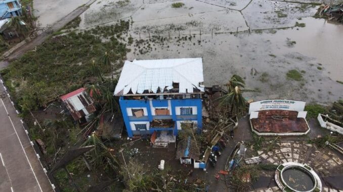
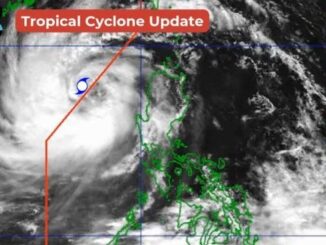
MANILA, Philippines — Ahead of its landfall on Sunday, November 17, tropical cyclone “Pepito” (international name: Man-Yi) maintained its super typhoon category strength as it heads for the vicinity of Aurora where it is likely to make a landfall by midday.
In its 11 a.m. bulletin, state weather bureau PAGASA estimated that Pepito is packing 185 kilometers per hour (kph) near the center and gusts reaching up to 230 kph—strength that has been unchanged since earlier on Sunday.
PAGASA located the eye of the powerful typhoon was 120 kilometers east-southeast of Baler, Aurora.
PAGASA
It is moving northwestward at a speed of 20 kph, with typhoon-force winds extending up to 300 kilometers from the center.
Tropical Cyclone Wind Signals
Signal No. 5
Pagasa has placed the eastern portion of Polillo Islands (Burdeos, Patnanungan and Jomalig) under Tropical Cyclone Wind Signal (TCWS) No. 5.
These areas are under an imminent and extreme threat, with destructive winds surpassing 185 kph anticipated within the next 12 hours.
Signal No. 4
Aurora
Quirino
Nueva Vizcaya
Southern Portion of Ifugao:
- Kiangan
- Lamut
- Tinoc
- Asipulo
- Lagawe
Southern Portion of Benguet:
- Bokod
- Itogon
- Tuba
- Baguio City
- Kabayan
- La Trinidad
- Sablan
- Tublay
- Kapangan
- Atok
Southern Portion of La Union:
- Burgos
- Naguilian
- Bauang
- Caba
- Tubao
- Pugo
- Aringay
- Santo Tomas
- Rosario
- Agoo
- Bagulin
- City of San Fernando
Eastern Portion of Pangasinan:
- Sison
- Tayug
- Binalonan
- San Manuel
- Umingan
- Asingan
- San Quintin
- Santa Maria
- Natividad
- San Nicolas
- Balungao
- Pozorrubio
- Laoac
- San Jacinto
- San Fabian
- Manaoag
- City of Urdaneta
- Villasis
- Rosales
Eastern Portion of Nueva Ecija:
- General Tinio
- Gabaldon
- Laur
- Bongabon
- Palayan City
- Pantabangan
- Rizal
- General Mamerto Natividad
- Lupao
- San Jose City
- Llanera
- Carranglan
Northern Portion of Quezon:
Including:
- The Rest of Polillo Islands
- Calaguas Islands
These areas face a significant to severe threat to life and property, with typhoon-force winds ranging from 118 to 184 kph expected within 12 hours.
Signal No. 3:
- Southern Portion of Isabela:
- San Agustin
- Jones
- Echague
- San Guillermo
- Angadanan
- Alicia
- San Mateo
- Ramon
- San Isidro
- City of Santiago
- Cordon
- Dinapigue
- Roxas
- San Manuel
- Aurora
- Cabatuan
- City of Cauayan
- Luna
- The Rest of Ifugao
- Mountain Province
- Southern Portion of Abra:
- Tubo
- Luba
- Pilar
- Villaviciosa
- San Isidro
- Pidigan
- Langiden
- San Quintin
- Ilocos Sur
- The Rest of Benguet
- The Rest of La Union
- The Rest of Pangasinan
- Northern Portion of Zambales:
- Santa Cruz
- Candelaria
- Masinloc
- Palauig
- Tarlac
- The Rest of Nueva Ecija
- Northern Portion of Pampanga:
- Candaba
- Arayat
- Magalang
- San Luis
- San Simon
- Mexico
- Santa Ana
- Apalit
- Santo Tomas
- City of San Fernando
- Mabalacat City
- Angeles City
- Northern Portion of Bulacan:
- Norzagaray
- San Miguel
- San Ildefonso
- San Rafael
- Doña Remedios Trinidad
- Angat
- City of San Jose del Monte
- Santa Maria
- Pandi
- Baliuag
- Bustos
- Pulilan
- Plaridel
- Northern Portion of Rizal:
- Pililla
- Tanay
- City of Antipolo
- Rodriguez
- Baras
- San Mateo
- Morong
- Teresa
- Eastern Portion of Laguna:
- Santa Maria
- Famy
- Mabitac
- Pakil
- Pangil
- Siniloan
- Paete
- Kalayaan
- Lumban
- Cavinti
- Central and Eastern Portion of Quezon:
- Real
- Perez
- Calauag
- Alabat
- Quezon
- Mauban
- Sampaloc
- Western Portion of Camarines Norte:
- Santa Elena
- Labo
- Capalonga
- Paracale
- Vinzons
- San Vicente
- Talisay
- Daet
- Jose Panganiban
These areas face a moderate to significant threat to life and property, with storm-force winds ranging from 118 to 184 kph expected within 18 hours.
Signal No. 2:
- The rest of Isabela
- Southwestern Portion of Mainland Cagayan:
- Enrile
- Tuao
- Solana
- Tuguegarao City
- Piat
- Rizal
- Kalinga
- Southern Portion of Apayao:
- The Rest of Abra
- Ilocos Norte
- The Rest of Zambales
- Bataan
- The Rest of Pampanga
- The Rest of Bulacan
- Metro Manila
- The Rest of Rizal
- Cavite
- The Rest of Laguna
- The Rest of Quezon
- The Rest of Camarines Norte
- Camarines Sur
- Western Portion of Catanduanes:
- Pandan
- Caramoran
- San Andres
These areas face a minor to moderate threat to life and property, with gale-force winds ranging from 62 to 88 kph expected within 24 hours.
Signal No. 1:
- The rest of mainland Cagayan
- The rest of Apayao
- Batangas
- The northern portion of Occidental Mindoro:
- Abra de Ilog
- Paluan
- Lubang Islands
- The northern portion of Oriental Mindoro:
- Puerto Galera
- San Teodoro
- Naujan
- Baco
- Victoria
- Socorro
- Pinamalayan
- Gloria
- Pola
- City of Calapan
- The northern portion of Romblon:
- Cajidiocan
- San Fernando
- Magdiwang
- Romblon
- Banton
- Corcuera
- Concepcion
- San Andres
- Calatrava
- San Agustin
- Marinduque
- The northern portion of Masbate:
- City of Masbate
- Mobo
- Aroroy
- Baleno
- Burias and Ticao Islands
- Albay
- Sorsogon
- The rest of Catanduanes
Coastal and marine hazards
The typhoon poses a high risk of life-threatening storm surges, with peak surge heights exceeding three meters over low-lying areas of Ilocos Region, Central Luzon, Metro Manila and Calabarzon.
Gale warnings remain in effect over the eastern and western seaboards of Luzon, with wave heights reaching up to 14 meters along Polillo Islands’ northern and eastern coasts.
The state weather bureau urged seafarers and marines to seek shelter due to the high risk of sea travel.
Forecast track
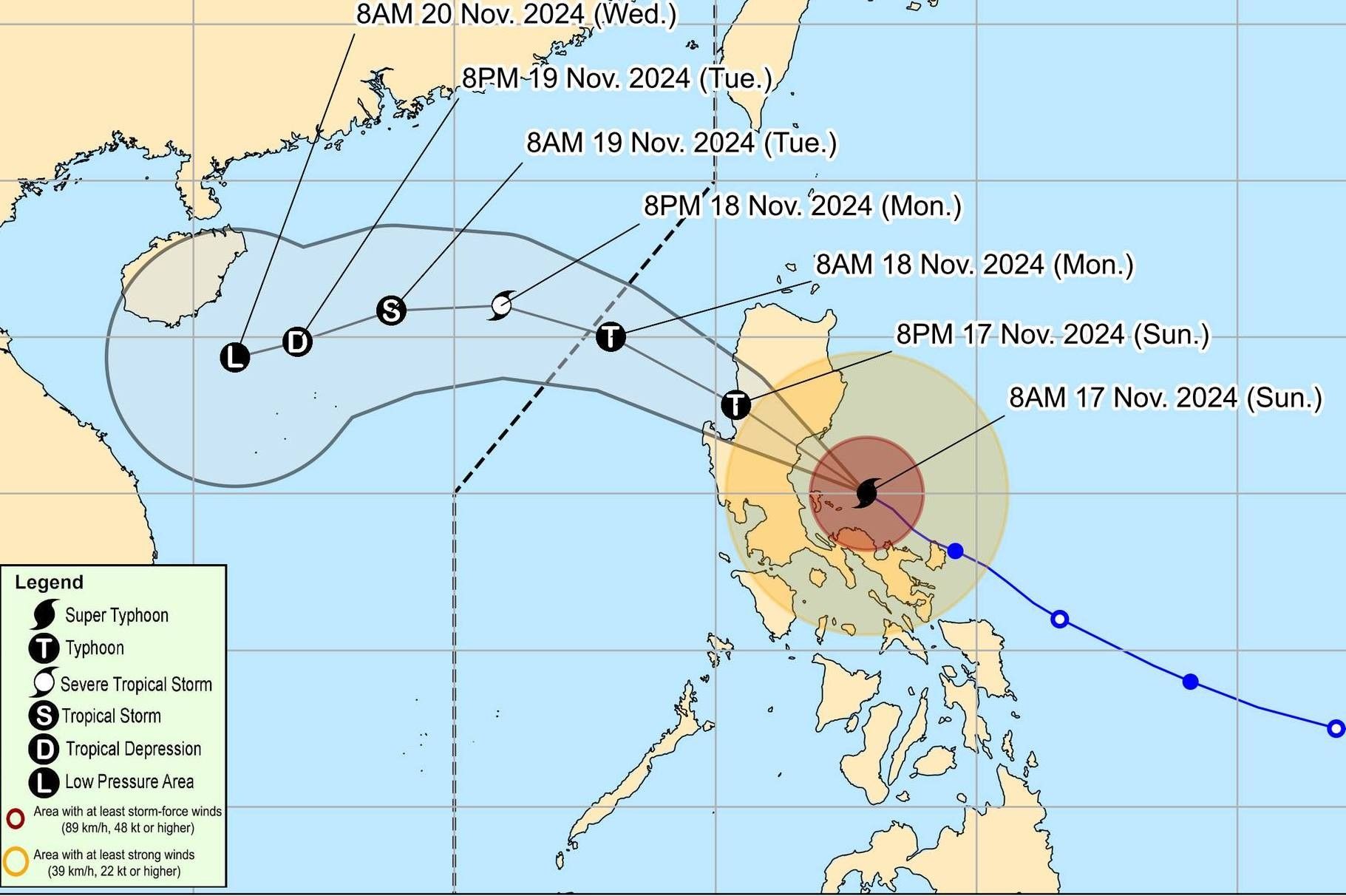
Pepito is expected to move generally west-northwestward or northwestward and is projected to make landfall near Aurora this afternoon. Afterward, it will traverse the northern part of Central Luzon and the southern portion of Northern Luzon, passing through the upland regions of the Sierra Madre, Caraballo and Cordillera Central between this afternoon and evening.
PAGASA
Over the West Philippine Sea, Pepito will continue its west-northwestward path on November 18, with the possibility of exiting the Philippine area of responsibility (PAR) by morning or noon of November 18.
Once it moves beyond the PAR, the storm is forecast to shift toward the west or west-southwest on Tuesday, 19 November, as an incoming northeasterly wind surge influences its trajectory.


Be the first to comment