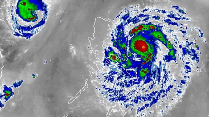
MANILA, Philippines — The state weather bureau has raised tropical cyclone wind signals, placing parts of Metro Manila under Signal No. 1 and eight other areas under Signal No. 2 due to Severe Tropical Storm Nika (international name: Toraji).
In its 11 a.m. weather bulletin, PAGASA said that Nika is maintaining its strength as it moves westward at 30 kilometers per hour over the Philippine Sea.
It was last spotted 500 kilometers east of Infanta, Quezon, bearing peak winds of 100 kilometers per hour and gustiness of up to 125 kph.
The storm is producing strong to storm-force winds extending 300 kilometers from its center, affecting various areas in northern and central Luzon.
Wind signals
The following areas are under tropical cyclone wind signals:
Signal No. 2
- northern and central portions of Aurora (Dilasag, Casiguran, Dinalungan, Dipaculao, Maria Aurora, Baler)
- Isabela
- Quirino
- southern portion of Cagayan (Solana, Iguig, Peñablanca, Tuguegarao City, Enrile)
- Nueva Vizcaya
- Kalinga
- Mountain Province
- Ifugao
Gale-force winds, ranging from 62 kph to 88 kph, could potentially cause minor to moderate impacts in these areas.
Signal No. 1
- rest of Cagayan including Babuyan Islands
- Apayao
- Abra
- Ilocos Norte
- Ilocos Sur
- eastern and central portions of Pangasinan (San Nicolas, Tayug, Natividad, San Quintin, Umingan, Basista, Villasis, Malasiqui, San Fabian, Urbiztondo, Bautista, Mangaldan, Mapandan, Rosales, Dagupan City, Binalonan, Aguilar, Alcala, San Manuel, Asingan, Santo Tomas, Pozorrubio, Santa Maria, City of Urdaneta, Laoac, Mangatarem, San Carlos City, Manaoag, Binmaley, San Jacinto, Bayambang, Calasiao, Santa Barbara, Balungao, Sison, Lingayen, Bugallon, Labrador)
- La Union
- Benguet
- rest of Aurora
- Tarlac
- Nueva Ecija
- Pampanga
- Bulacan
- northern portion of Metro Manila (City of Navotas, City of Valenzuela, City of Malabon, Caloocan City, City of Marikina, City of Pasig, Quezon City)
- Rizal
- northeastern portion of Laguna (Santa Maria, Mabitac, Pakil, Pangil, Famy, Siniloan, Paete, Kalayaan, Cavinti, Lumban, Luisiana)
- eastern portion of Quezon (Calauag, Guinayangan, Tagkawayan, Pitogo, San Andres, Buenavista, San Francisco, Pagbilao, Infanta, Lopez, Catanauan, Mulanay, Unisan, General Luna, Plaridel, Quezon, Alabat, Sampaloc, Padre Burgos, Macalelon, Mauban, Perez, Agdangan, Gumaca, Atimonan, Real, San Narciso, General Nakar, Lucban, City of Tayabas, Lucena City) including Pollilo Islands
- Camarines Norte
- Camarines Sur
- Catanduanes
- Albay (Malinao, Tiwi, Bacacay, City of Tabaco, Malilipot, Rapu-Rapu)
Areas under Signal No. 1 may experience possible minimal to minor impacts from strong winds, ranging from 39 kph to 61 kph.
Heavy rains, severe winds
PAGASA said that heavy rainfall is expected in areas under Signal No. 2 over the next 24 hours. Some areas could experience 100–200 mm of rain, increasing the risk of flooding and landslides.
The highest wind signal that may be raised is Signal No. 4.
The northeasterly wind flow is expected to bring strong to gale-force gusts over the following areas in the coming days:
- Sunday, November 10: Batanes, Babuyan Islands, northern Cagayan and Ilocos Norte
- Monday, November 11: Batanes, Camarines Sur and Catanduanes
- Tuesday, November 12: Batanes and Cagayan including Babuyan Islands
Storm surge, sea conditions
A moderate to high risk of storm surges is expected in exposed coastal areas, particularly in the eastern seaboard of southern Luzon, including parts of Quezon, Aurora and Isabela.
The state weather bureau issued a gale warning for coastal waters, particularly over the eastern seaboard of southern Luzon.
It also warned the public to avoid traveling by sea due to dangerous conditions in the following coastal water areas:
- Up to 7 meters: seaboards of Isabela and northern Aurora
- Up to 5.5 meters: remaining seaboard of Aurora, northern and eastern seaboards of Polillo Islands; seaboard of Camarines Norte
- Up to 4.5 meters: eastern seaboard of mainland Cagayan; northern seaboards of Camarines Sur and Catanduanes
- Up to 4 meters: remaining seaboard of Catanduanes
- Up to 3.5 meters: seaboards of Ilocos Norte, Ilocos Sur, Batanes, and Babuyan Islands; remaining seaboard of mainland Cagayan
- Up to 3 meters: eastern seaboards of mainland Quezon, Albay and Sorsogon; northern seaboard of Northern Samar; remaining seaboard of Ilocos Region and Polillo Islands
- Up to 2.5 meters: eastern seaboard of Northern Samar
- Up to 2 meters: eastern seaboards of Eastern Samar and Dinagat Islands; seaboard of Kalayaan Islands
Track, intensity outlook
Severe Tropical Storm Nika is expected to make landfall in Isabela or Aurora on Monday, November 11, as it moves west-northwestward across the Philippine Sea.
According to PAGASA, Nika may develop into a typhoon on Sunday, potentially peaking before landfall. After crossing northern Luzon, the storm will emerge over the West Philippine Sea by Monday evening.
Although landfall is expected in Isabela or Aurora, the state weather bureau warned that areas outside the direct path may still experience heavy rain, strong winds and storm surges.
It is expected to weaken as it moves over land but may strengthen again once it reaches the sea.
Nika may leave the Philippine area of responsibility by Tuesday, November 12.


Be the first to comment