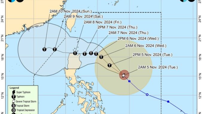
MANILA, Philippines — Signal No. 1 has been raised over parts of Northern Luzon as Severe Tropical Storm “Marce” has slightly intensified and nearing typhoon category, the state-run weather agency said on Tuesday.
Affected areas include Batanes, Cagayan including Babuyan Islands, the northern and eastern portions of Isabela (Maconacon, San Pablo, Palanan, Dinapigue, Santa Maria, Cabagan, Tumauini, Santo Tomas, Ilagan City, Divilacan and San Mariano), the northern portion of Apayao (Santa Marcela, Luna, Calanasan, Flora and Pudtol), and the northern portion of Ilocos Norte (Pagudpud, Dumalneg, Adams, Bangui, Burgos, Pasuquin and Vintar).
Packing maximum sustained winds of 110 kilometers per hour (kph) near the center and gustiness of up to 135kph, the center of the eye of Marce was estimated at 735 kilometers east of Baler, Aurora while moving north-westward at 25kph, the Philippine Atmospheric Geophysical and Astronomical Services Administration (Pagasa) said in its 5 a.m. bulletin.
Marce is currently undergoing rapid intensification, said Pagasa administrator Nathaniel Servando.
“This tropical cyclone is expected to continue to rapidly intensify and may reach typhoon category within the day (Tuesday),” he said.
The Pagasa chief added that the severe tropical storm would reach its peak intensity prior to possible landfall over Babuyan Islands of Cagayan either Thursday evening or early Friday morning.
The state weather bureau said the Bicol region, Eastern Visayas and the provinces of Quezon, Aurora and Kalinga would be experiencing either scattered or isolated rain showers and thunderstorms due to Marce.
Meanwhile, Metro Manila and the rest of the country will likely have partly cloudy to overcast skies with isolated downpours or thunderstorms due to localized thunderstorms, the latest Pagasa bulletin said.


Be the first to comment