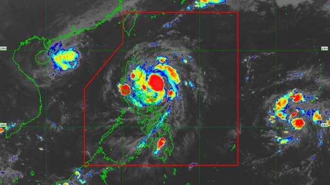
MANILA, Philippines — PAGASA raised Signal No. 3 over parts of Isabela and Aurora as Severe Tropical Storm Nika (international name: Toraji) slightly decelerated while moving over the Philippine Sea on Sunday evening, November 10.
As of 7 p.m., Nika was spotted 330 kilometers east of Baler, Aurora.
It is carrying peak winds of 110 kilometers per, with gusts reaching up to 135 kph.
Moving west-northwestward at 15 kph, Nika is expected to make landfall over Isabela or northern Aurora by Monday morning or early afternoon, November 11.
Wind signals
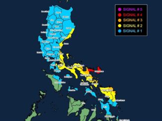
The following areas in Luzon are under tropical cyclone wind signals:
Signal No. 3
- southeastern portion of Isabela (Dinapigue, Palanan)
- northern portion of Aurora (Dilasag, Casiguran, Dinalungan)
Winds between 89 kph to 117 kph may be expected in at least 18 hours. Residents of areas under Signal No. 3 could experience moderate to significant impacts from strong winds.
Signal No. 2
- southern portion of Ilocos Norte (Nueva Era, Solsona, Dingras, Marcos, Banna, City of Batac, Pinili, Paoay, Currimao, Badoc, Carasi, Piddig, Sarrat, San Nicolas, Laoag City)
- Ilocos Sur
- La Union
- northeastern portion of Pangasinan (San Nicolas, Natividad, San Quintin, Sison, San Manuel, Umingan, Tayug)
- central portion of Aurora (Dipaculao, Maria Aurora, Baler)
- southern portion of mainland Cagayan (Solana, Iguig, Peñablanca, Tuguegarao City, Enrile, Baggao, Alcala, Amulung, Santo Niño, Rizal, Piat, Tuao, Gattaran, Lasam)
- rest of Isabela
- Quirino
- Nueva Vizcaya
- southern portion of Apayao (Kabugao, Conner, Flora, Pudtol, Calanasan)
- Abra
- Kalinga
- Mountain Province
- Ifugao
- Benguet
- northern portion of Nueva Ecija (Carranglan, Pantabangan, Lupao, San Jose City)
Residents of areas under Signal No. 2 could experience minor to moderate impacts from strong winds, with winds between 62 kph and 88 kph expected within at least 24 hours.
Signal No. 1
- rest of Cagayan including Babuyan Islands
- rest of Apayao
- rest of Ilocos Norte
- rest of Pangasinan
- rest of Aurora
- Tarlac
- northern and central portions of Zambales (Santa Cruz, Candelaria, Masinloc, Palauig, Iba, Botolan, Cabangan, San Marcelino, San Felipe, San Narciso)
- rest of Nueva Ecija
- Pampanga
- Bulacan
- Metro Manila
- Rizal
- eastern portion of Laguna (Santa Maria, Mabitac, Pakil, Pangil, Famy, Siniloan, Paete, Kalayaan, Cavinti, Lumban, Luisiana, Santa Cruz, Magdalena, Pagsanjan, Majayjay, Liliw, Nagcarlan, Pila, Victoria)
- eastern portion of Quezon (Calauag, Guinayangan, Tagkawayan, Pitogo, San Andres, Buenavista, San Francisco, Pagbilao, Infanta, Lopez, Catanauan, Mulanay, Unisan, General Luna, Plaridel, Quezon, Alabat, Sampaloc, Padre Burgos, Macalelon, Mauban, Perez, Agdangan, Gumaca, Atimonan, Real, San Narciso, General Nakar, Lucban, City of Tayabas, Lucena City) including Polillo Islands
- Camarines Norte
- Camarines Sur
- Catanduanes
- northeastern portion of Albay (Malinao, Tiwi, Bacacay, City of Tabaco, Malilipot, Rapu-Rapu)
Winds between 39 and 61 kph may be expected in at least 36 hours or intermittent rains may be expected within 36 hours. Minimal to minor impacts from strong winds are anticipated.
Severe winds
PAGASA warned the highest wind signal, No. 4, may be raised in some areas due to Severe Tropical Storm Nika.
It also issued a warning for strong to gale-force gusts due to the northeasterly wind flow in the following areas:
- Sunday, November 10: Batanes
- Monday, November 11: Batanes, Batangas, Marinduque, Romblon, Camarines Sur and Catanduanes
- Tuesday, November 12: Batanes and Cagayan including Babuyan Islands
Storm surge, sea conditions
The state weather bureau has warned of moderate to high-risk storm surges in the next 48 hours for coastal areas in Ilocos Norte, Ilocos Sur, La Union, Pangasinan, Cagayan (including Babuyan Islands), Isabela, Zambales, Aurora, Quezon (including Polillo Islands), Camarines Norte, Camarines Sur and Catanduanes.
Gale warnings have been issued for the eastern seaboards of Luzon.
Sea travel is discouraged in these areas, especially along the coasts of Isabela, northern Aurora and eastern seaboards of Polillo Islands, Camarines Norte and Catanduanes.
PAGASA has also advised mariners to seek shelter and stay in port as high waves of up to 7 meters could make sea travel dangerous.
Track, intensity outlook
Nika is set to make landfall in Isabela or northern Aurora on the morning or early afternoon of November 11.
Areas outside the expected landfall zone will still be affected by strong winds and heavy rains, according to PAGASA. After crossing northern Luzon, Nika is expected to emerge over the West Philippine Sea by Monday evening.
The state weather bureau said Nika is expected to become a typhoon on Sunday, with winds reaching up to 130 kph before landfall. It may weaken briefly over land but could regain strength once over the sea.
It may leave the Philippine area of responsibility by Tuesday afternoon, November 12.


Be the first to comment