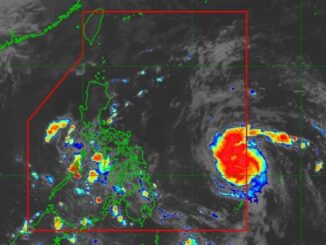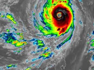
MANILA, Philippines (Updated at 9 a.m.) — Typhoon Nika (international name: Toraji) has further grown in wind speed and is expected to make landfall over Isabela or northern Aurora on Monday, November 11.
As 7 a.m., state weather bureau PAGASA located the center of Typhoon Nika over the coastal waters of Dilasag, Aurora with maximum sustained winds of 130 kilometers per hour (kph) near the center, gustiness of up to 180 kph.
It is presently moving at a pace of 15 kph at a west northwestward direction.
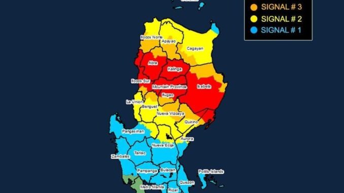
PAGASA has raised various storm signals across Luzon due to the typhoon’s expected impact:
Signal No. 4 (Typhoon-force winds)
- The northernmost portion of Aurora (Dilasag, Casiguran)
- The central and southern portions of Isabela (Dinapigue, San Mariano, San Guillermo, Jones, Echague, Ramon, San Isidro, City of Santiago, Cordon, Roxas, Burgos, Reina Mercedes, Naguilian, Benito Soliven, Gamu, San Manuel, Aurora, San Mateo, Cabatuan, Alicia, Luna, City of Cauayan, Angadanan, Quezon, Mallig, Quirino, Ilagan City, Delfin Albano, San Agustin)
- Kalinga
- Mountain Province
- The northern portion of Ifugao (Aguinaldo, Mayoyao, Alfonso Lista, Banaue, Hungduan, Hingyon, Lagawe)
- The central and southern portion of Abra (Manabo, Pidigan, San Juan, Tayum, Langiden, Luba, Boliney, Sallapadan, Bucloc, Lagangilang, Tubo, Danglas, Villaviciosa, La Paz, Licuan-Baay, Pilar, Malibcong, Pe, San Isidro, Daguioman, San Quintin, Dolores, Lagayan, Bangued, Bucay, Lacub)
- The northern and central portions of Ilocos Sur (Cabugao, Sinait, San Juan, San Emilio, Lidlidda, Banayoyo, Santiago, San Esteban, Burgos, Santa Maria, Magsingal, San Vicente, Santa Catalina, Nagbukel, San Ildefonso, City of Vigan, Caoayan, Santa, Bantay, Santo Domingo, Narvacan, Quirino, Cervantes, Sigay, Salcedo, Santa Lucia, City of Candon, Galimuyod, Gregorio del Pilar, Santa Cruz)
Signal No. 3 (Storm-force winds)
- The central portion of Aurora (Dinalungan)
- The northern portion of Quirino (Diffun, Cabarroguis, Aglipay, Saguday, Maddela)
- The northeastern portion of Nueva Vizcaya (Diadi, Bagabag, Quezon, Solano, Villaverde, Kasibu, Ambaguio, Bayombong)
- The rest of Isabela
- The southwestern portion of Cagayan (Enrile, Solana, Tuao, Tuguegarao City, Rizal, Piat)
- The rest of Abra
- The rest of Ifugao
- The northern portion of Benguet (Buguias, Mankayan, Bakun)
- The southern portion of Ilocos Norte (Laoag City, Sarrat, San Nicolas, Piddig, Marcos, Nueva Era, Dingras, Bacarra, Solsona, Paoay, Currimao, Pinili, Badoc, City of Batac, Banna)
- The rest of Ilocos Sur
Signal No. 2 (Gale-force winds)
- The northwestern and eastern portions of Cagayan (Iguig, Peñablanca, Baggao, Alcala, Amulung, Santo Niño, Gattaran, Lasam, Santa Praxedes, Claveria, Sanchez-Mira, Pamplona, Abulug, Allacapan, Ballesteros, Lal-Lo, Aparri, Camalaniugan, Buguey, Santa Teresita, Gonzaga)
- The rest of Nueva Vizcaya
- The rest of Quirino
- Tthe rest of Apayao
- The rest of Benguet
- The rest of Ilocos Norte
- La Union
- The northeastern portion of Pangasinan (San Nicolas, Natividad, San Quintin, Sison, San Manuel, Umingan, Tayug)
- The central portion of Aurora (Dipaculao, Maria Aurora, Baler)
- Tthe northern portion of Nueva Ecija (Carranglan, Pantabangan, Lupao, San Jose City)
Signal No. 1 (Strong winds)
- Babuyan Islands
- The rest of mainland Cagayan
- The rest of Pangasinan
- The rest of Aurora
- The rest of Nueva Ecija
- Bulacan
- Pampanga
- Tarlac
- The northern and central portions of Zambales (Santa Cruz, Candelaria, Masinloc, Palauig, Iba, Botolan, Cabangan, San Marcelino, San Felipe, San Narciso)
- Metro Manila
- Rizal
- The eastern portion of Laguna (Santa Maria, Mabitac, Pakil, Pangil, Famy, Siniloan, Paete, Kalayaan, Cavinti, Lumban, Luisiana, Santa Cruz, Magdalena, Pagsanjan, Pila)
- The northern and eastern portions of Quezon (Infanta, Quezon, Alabat, Sampaloc, Mauban, Perez, Real, General Nakar, Calauag) including Pollilo Islands
- The northwestern portion of Camarines Norte (Capalonga, Santa Elena, Vinzons, Labo, Paracale, San Vicente, Talisay, Daet, Jose Panganiban)
Residents in these areas are advised to take necessary precautions and follow evacuation instructions from local officials.
Forecast track
PAGASA forecasts Nika to generally move west northwestward until Thursday, November 14. It may then turn generally southwestward on Friday, November 15 and onward.
It is expected to make landfall over Isabela or northern Aurora on Monday morning, Novermber 11. It will then traverse the landmass of mainland Luzon and emerge over the sea west of Ilocos Sur on Monday evening.
PAGASA
The cyclone will continue to move west northwestward over West Philippine Sea and exit the Philippine area of responsibility by Tuesday, November 12 in the morning or afternoon, PAGASA said.
Its most current intensification, however, would be temporary as it will likely weaken into a severe tropical storm once it hits land. “A generally weakening trend may then be expected for this tropical cyclone until it becomes a remnant low over the sea near southern China,” the bureau added.


Be the first to comment