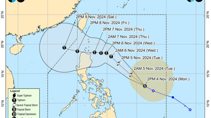
The state weather bureau warned residents of northern Luzon to prepare for the possible heavy rains that tropical storm “Marce” may bring as it intensified over the Philippine Sea east of Bicol region.
“Marce’s track is in the middle of ‘Kristine’ and ‘Leon’s track. Those in areas affected by the two cyclones should prepare as these are the same areas that may be affected by Marce,” PAGASA meteorologist Veronica Torres said.
Based on the forecast track, “Marce” will make landfall in the vicinity of Babuyan Islands or mainland northern Cagayan on Thursday evening or Friday early morning.
Due to the uncertainty in the strength of the high pressure area north of “Marce,” the forecast track may still change and bring the landfall point to mainland Cagayan-Isabela area, PAGASA said.
PAGASA said wind signals may be raised over parts of northern Luzon beginning today (Tuesday) in anticipation of the storm’s strong winds.
“Those living in areas far from the storm’s immediate path should be on alert as they can also experience gusty winds and light to moderate rains,” weather division officer-in-charge Chris Perez said.
“Marce” may reach the severe tropical storm category Tuesday morning, and may intensify to typhoon category by Wednesday early morning, PAGASA said.
“Tropical Cyclone Wind Signal No. 1 may be hoisted over portions of Cagayan tonight or tomorrow morning. The highest Wind Signal which may be hoisted during the occurrence of ‘Marce’ is Wind Signal No. 4.”
Rapid intensification is likely, the state weather bureau said.
The center of “Marce” was last spotted Monday at 740 kilometers east of Virac, Catanduanes.
It was moving west northwestward at 30 km/h with maximum sustained winds of 85 km/h near the center and gustiness of up to 105 km/h.
Editor’s Note: This is an updated article. Originally posted with the headline “Marce’ intensifies but no wind signals hoisted yet.”


Be the first to comment