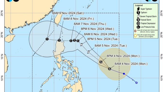
Tropical Storm “Marce” (International Name: Yinxing) slightly intensifies as it moves west northwestward over the Philippine sea, the state weather bureau said.
According to the latest 11 AM advisory from the Philippine Atmospheric, Geophysical and Astronomical Services Administration (PAGASA), “Marce” is moving west northwestward at 35 kilometers per hour with maximum sustained winds of 75 kilometers per hour near the center and gustiness of up to 90 kilometers per hour.
Its center was last estimated at 775 km east of Borongan City, Eastern Samar.
As the tropical storm moves northwestward within the PAR region, it may enhance the northeasterly wind flow which may occur within the week.
The trough of the tropical cyclone is expected to bring rains over extreme Northern Luzon and the eastern section of Luzon beginning today or on Tuesday.
While no Tropical Cyclone Wind Signal (TCWS) is raised at the moment, TCWS No. 1 may be raised over portions of Cagayan by tomorrow, and the highest wind signal during the occurrence of “Marce” in TCWS No. 4.
“This tropical cyclone is expected to gradually intensify and may reach severe tropical storm category by tomorrow. Furthermore, it may also reach typhoon category by tomorrow evening or Wednesday early morning. Rapid intensification is likely,” PAGASA warned.
The tropical storm will move generally west northwestward today until tomorrow before turning westward at a slow pace over the Philippine Sea east of extreme Northern Luzon.
Meanwhile, on the track forecast, the weather disturbance will make landfall in the vicinity of Babuyan Islands or mainland northern Cagayan on Thursday evening or Friday early morning.
“Due to uncertainty in the strength of the high pressure area north of “Marce,” the forecast track may still change and bring the landfall point to mainland Cagayan-Isabela area.”


Be the first to comment