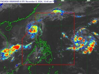
MANILA, Philippines — Typhoon Nika (international name: Toraji) has grew in wind speed and is expected to make landfall over Isabela or northern Aurora on Monday, November 11.
As 4:00 a.m., state weather bureau PAGASA located the center of Typhoon Nika at 100 kilometers east southeast of Casiguran, Aurora with maximum sustained winds of 120 kilometers per hour (kph) near the center, gustiness of up to 150 kph.
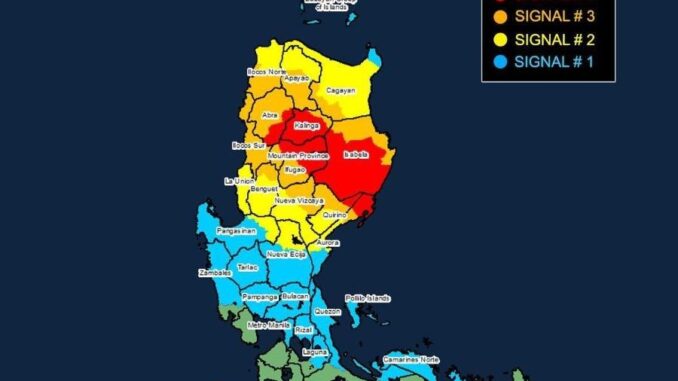
PAGASA has raised various storm signals across Luzon due to the typhoon’s expected impact:
Signal No. 4 (Typhoon-force winds)
- The northernmost portion of Aurora (Dilasag, Casiguran)
- The central and southern portions of Isabela (Dinapigue, San Mariano, San Guillermo, Jones, Echague, Ramon, San Isidro, City of Santiago, Cordon, Roxas, Burgos, Reina Mercedes, Naguilian, Benito Soliven, Gamu, San Manuel, Aurora, San Mateo, Cabatuan, Alicia, Luna, City of Cauayan, Angadanan, Quezon, Mallig, Quirino, Ilagan City, Delfin Albano, San Agustin)
- The southeastern portion of Abra (Tubo, Boliney, Daguioman, Bucloc, Malibcong), the central and eastern portions of Mountain Province (Sadanga, Bontoc, Barlig, Natonin, Paracelis)
- The eastern portion of Ifugao (Aguinaldo, Mayoyao, Alfonso Lista)
- The western and southern portions of Kalinga (Tanudan, Tinglayan, Pasil, Lubuagan, Balbalan, City of Tabuk).
Signal No. 3 (Storm-force winds)
- The northern portion of Aurora (Dinalungan)
- The northeastern portion of Nueva Vizcaya (Diadi, Bagabag, Quezon, Solano, Villaverde, Kasibu, Ambaguio, Bayombong)
- The northern portion of Quirino (Diffun, Cabarroguis, Aglipay, Saguday, Maddela)
- The rest of Isabela
- The southwestern portion of Cagayan (Enrile, Solana, Tuao, Tuguegarao City, Rizal, Piat)
- The rest of Abra, the southern portion of Apayao (Conner, Kabugao)
- The rest of Kalinga, the rest of Mountain Province
- The rest of Ifugao, the northern portion of Benguet (Buguias, Mankayan, Bakun)
- The southern portion of Ilocos Norte (Laoag City, Sarrat, San Nicolas, Piddig, Marcos, Nueva Era, Dingras, Bacarra, Solsona, Paoay, Currimao, Pinili, Badoc, City of Batac, Banna), and Ilocos Sur.
Signal No. 2 (Gale-force winds)
- The central portion of Aurora (Dipaculao, Maria Aurora, Baler)
- The rest of Nueva Vizcaya, the rest of Quirino
- The northwestern and eastern portions of Cagayan (Iguig, Peñablanca, Baggao, Alcala, Amulung, Santo Niño, Gattaran, Lasam, Santa Praxedes, Claveria, Sanchez-Mira, Pamplona, Abulug, Allacapan, Ballesteros, Lal-Lo, Aparri, Camalaniugan, Buguey, Santa Teresita, Gonzaga)
- The rest of Apayao, the rest of Benguet, the rest of Ilocos Norte, La Union
- The northeastern portion of Pangasinan (San Nicolas, Natividad, San Quintin, Sison, San Manuel, Umingan, Tayug)
- The northern portion of Nueva Ecija (Carranglan, Pantabangan, Lupao, San Jose City)
Signal No. 1 (Strong winds)
- The rest of Aurora, the rest of Cagayan including Babuyan Islands, the rest of Pangasinan
- The rest of Nueva Ecija, Bulacan, Pampanga, Tarlac
- The northern and central portions of Zambales (Santa Cruz, Candelaria, Masinloc, Palauig, Iba, Botolan, Cabangan, San Marcelino, San Felipe, San Narciso)
- Metro Manila
- Rizal
- The eastern portion of Laguna (Santa Maria, Mabitac, Pakil, Pangil, Famy, Siniloan, Paete, Kalayaan, Cavinti, Lumban, Luisiana, Santa Cruz, Magdalena, Pagsanjan, Majayjay, Liliw, Nagcarlan, Pila, Victoria)
- The northern and eastern portions of Quezon (Calauag, Infanta, Quezon, Alabat, Sampaloc, Mauban, Perez, Real, General Nakar, Tagkawayan, Guinayangan) including Pollilo Islands
- Camarines Norte
- The northeastern portion of Camarines Sur (Siruma, Tinambac, Garchitorena, Lagonoy)
Residents in these areas are advised to take necessary precautions and follow evacuation instructions from local officials.
Forecast track
The typhoon, moving west northwesward until Thursday, November 14, is expected to traverse mainland Luzon on Monday and emerge over the West Philippine Sea this evening before exiting the Philippine area of responsibility by Tuesday morning or afternoon, November 12.
Nika is also expected to further intensify over the next hours prior to landfall. It may weaken into a severe tropical storm while traversing mainland Luzon due to land interaction.
After traversing Luzon, a generally weakening trend may be expected for this tropical cyclone until it becomes a remnant low over the sea near southern China.
PAGASA also warns of heavy rainfall and storm surges that may affect various parts of Luzon.


Be the first to comment