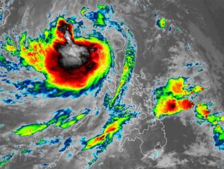
MANILA, Philippines — State weather bureau PAGASA has spotted a new low pressure area east of Mindanao, a day after Typhoon Carina (international name: Gaemi) left the Philippine area of responsibility.
According to PAGASA’s 24-hour public weather forecast issued at 4 a.m. Friday, the LPA was last seen 1,035 kilometers east of southeastern Mindanao at 3 a.m.
While it’s unlikely, PAGASA has not ruled out the possibility that the LPA will develop into a tropical cyclone by Sunday, Obet Badrina, PAGASA weather specialist, told Super Radyo DZBB on Friday.
The LPA is expected to bring cloudy skies to the eastern portion of Visayas and Mindanao over the weekend, according to PAGASA.
Rainfall outlook
Meanwhile, the western portion of Luzon that was pummeled with heavy rains in the past few days may see improved weather conditions, though PAGASA said heavy rains can be expected in some areas due to the continued effects of the southwest monsoon.
PAGASA said Ilocos Region, Batanes and Babuyan Islands are expected to continue experiencing monsoon rains caused by the southwest monsoon, with possible flooding or landslides due to heavy or intense rains with at times torrential rains.
Meanwhile, Zambales, Pampanga and Benguet will experience occasional rains caused by the southwest monsoon, with possible flash floods or landslides due to moderate to heavy rains with at times intense rains.
Metro Manila and the rest of Luzon can expect cloudy skies with scattered rains and thunderstorms. Rain caused by the southwest monsoon could still lead to flash floods or landslides due to moderate to at times heavy rains.


Be the first to comment