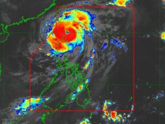
MANILA, Philippines — The southwest monsoon is still prevalent in northern and central Luzon on Thursday, August 8 despite the presence of a tropical cyclone outside the Philippines’ vicinity.
Cyclone outside PAR. State weather bureau PAGASA, in its 4 a.m. advisory, said the tropical cyclone, which intensified into Tropical Storm Maria since Wednesday, was recorded 2,230 kilometers east northest of extreme northern Luzon.
Since it is outside the Philippine area of responsibility, it has not yet adopted a local name. It is not expected to have any direct affect in the country and it so far poses no threat.
As of early Thursday, it packed maximum sustained winds of 65 kilometers per hour (kph) and gustiness of up to 80 kph. It is moving east northeastward at 15 kph.
Forecast
Ilocos Region, Zambales and Bataan will experience cloudy skies with scattered rains and thunderstorms due to the southwest monsoon, locally known as “habagat,” This may lead to possible flash floods or landslides due to moderate to at times heavy rains.
Partly cloudy to cloudy skies with isolated rainshowers or thunderstorms, meanwhile, are expected over Cordillera Administrative Region, Cagayan Valley, and the rest of Central Luzon, also caused by the southwest monsoon.
Metro Manila and the rest of the country will have partly cloudy to cloudy skies with isolated rainshowers or thunderstorms due to localized thunderstorms. These conditions may cause flash floods or landslides during severe thunderstorms.
Winds will be light to moderate, coming from the southeast to southwest direction. Coastal waters will be slight to moderate, with wave heights ranging from 0.6 to 2.1 meters.


Be the first to comment