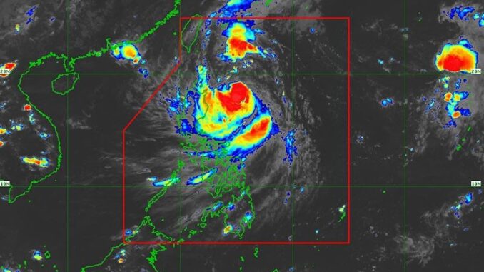
MANILA, Philippines — Tropical Storm Julian (international name: Krathon) has slightly strengthened while moving over the Philippine Sea.
In its 5 p.m. weather bulletin, state weather bureau PAGASA said that Julian was spotted 380 kilometers east of Aparri, Cagayan.
Moving west-northwest at 15 kilometers per hour, Julian was carrying peak winds of 75 kph and gusts of up to 90 kph.
Wind Signal
PAGASA hoisted Tropical Cyclone Wind Signal (TCWS) No. 1 over the following areas:
- Batanes
- Cagayan, including Babuyan Islands
- Isabela
- Apayao
- Kalinga
- The eastern portions of Mountain Province (Natonin, Paracelis) and Ifugao (Aguinaldo, Alfonso Lista)
- Ilocos Norte
- Abra
- northern portion of Aurora (Dilasag, Casiguran)
Residents in these areas can expect winds between 39 to 61 kph within the next 36 hours. PAGASA also warned of minimal to minor threats to life and property due to strong winds.
Heavy rainfall, severe winds
The state weather bureau warned of heavy rainfall, particularly for coastal and upland areas due to Tropical Storm Julian.
TCWS No. 4 may be raised if conditions worsen.
Julian is expected to bring strong to gale-force gusts over the following areas in the next few days:
- Sunday, September 29: Aurora, CALABARZON, Romblon and Bicol Region
- Monday, September 30: Aurora, Pangasinan, Zambales, Bataan, Metro Manila, CALABARZON, Romblon and Bicol Region.
Hazards affecting coastal waters
PAGASA advised mariners to remain in port due to dangerous sea conditions.
Very rough seas are expected, with wave heights reaching up to 6.0 meters along the coasts of Batanes and up to 5.0 meters around the Babuyan Islands.
According to PAGASA, small boats should not venture out under these conditions and other vessels.
Track and intensity outlook
Julian is expected to move west-southwest on Saturday, then northwest toward Batanes and Babuyan Islands early next week.
It is likely to strengthen into a typhoon by Monday, with a chance of becoming a super typhoon.


Be the first to comment