


October 25, 2024 | 12:18pm
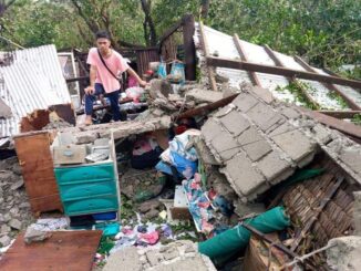
MANILA, Philippines — Severe Tropical Storm Kristine will exit the Philippine area of responsibility (PAR) by this afternoon, October 25, but the state weather bureau said that the cyclone may curve back towards the country by Monday, October 28.
PAGASA said the development would depend on the tropical depression hovering east of the PAR.
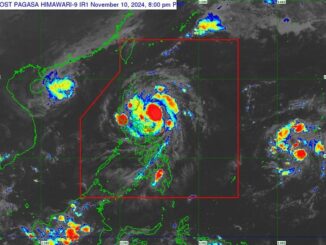
“In the extended outlook, there is a developing forecast situation wherein Kristine will continue moving westward over the West Philippine Sea until tomorrow, loop counterclockwise on Sunday and Monday, then move eastward for the remainder of the forecast period,” PAGASA said in its 11 a.m. cyclone bulletin.
As of 10 a.m., PAGASA said Kristine’s center was located 255 kilometers west northwest of Bacnotan, La Union. It packs maximum sustained winds of 95 km per hour and gustiness of up to 115 kph.
While it is likely to remain as a severe tropical storm, there is still a chance that Kristine will intensify into a typhoon once it is suspended over the West Philippine Sea
PAGASA issued several tropical cyclone wind signals (TCWS) in several areas:
TCWS No. 2:
- Luzon: Northwestern portion of mainland Cagayan (Santa Praxedes, Claveria, Sanchez-Mira, Abulug, Pamplona), the Babuyan Islands, Nueva Vizcaya, Apayao, Abra, Kalinga, Mountain Province, Ifugao, Benguet, Ilocos Norte, Ilocos Sur, La Union, Pangasinan, Nueva Ecija, Tarlac, Pampanga, Zambales, and the northern portion of Bataan (Morong, Hermosa, Dinalupihan, Bagac, Orani, Samal, Abucay, City of Balanga)
TCWS No. 1
- Luzon: Batanes, the rest of mainland Cagayan, Isabela, Quirino, Aurora, Bulacan, the rest of Bataan, Metro Manila, Cavite, Batangas, Laguna, Rizal, Quezon, Occidental Mindoro, Oriental Mindoro, Marinduque, Romblon, the northern portion of Palawan (El Nido, Taytay, San Vicente, Dumaran, Araceli) including Calamian, Cuyo, and Kalayaan Islands, Camarines Norte, Camarines Sur, and Burias Island
- Visayas: Northern portion of Aklan (Buruanga, Malay, Nabas, Ibajay), and the northern portion of Antique (Libertad, Pandan) including Caluya Islands
PAGASA has also issued a gale warning over the seaboards of Luzon and the western seaboard of Visayas.
Another tropical depression is hovering east of the PAR, 2,245 km east of Eastern Visayas.

Be the first to comment