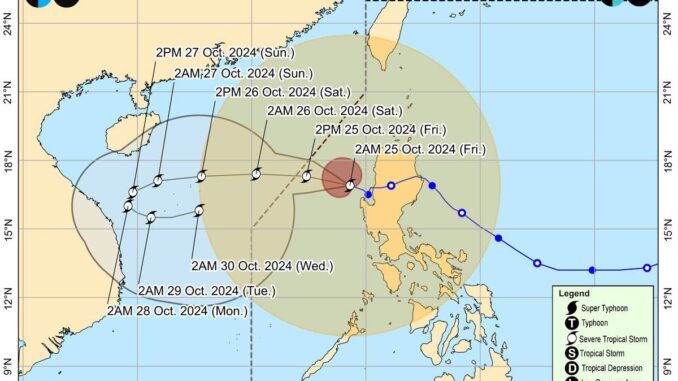
MANILA, Philippines — Severe Tropical Storm “Kristine” is forecast to exit the Philippine Area of Responsibility (PAR) on Friday afternoon but will continue to dump heavy rains and lash strong winds in many areas, especially in Luzon, the state-run weather agency said.
Weather specialist Benison Estareja of the Philippine Atmospheric Geophysical and Astronomical Services Administration (Pagasa) said in a 5 a.m. press briefing that Kristine would continue to traverse the West Philippine Sea and “exit PAR this (Friday) afternoon.”
Estareja said, however, that Kristine may reenter the PAR as it may slow down while moving away from the country and loop toward Luzon by Monday evening because of another low pressure area (LPA) that Pagasa is monitoring and which may affect “Kristine.”
“Reentry to PAR and landfall are not ruled out,” Pagasa administrator Nathaniel Servando told The Manila Times in a separate Viber interview.
In its 5 a.m. bulletin, the state weather bureau said Signal No. 3 was lifted in affected areas, especially in Northern Luzon.
But Signal No. 2 remains up over Cagayan including Babuyan Islands, Isabela, Quirino, Nueva Vizcaya, Apayao, Kalinga, Abra, Ifugao, Mountain Province, Benguet, Ilocos Norte, Ilocos Sur, La Union, Pangasinan, Aurora, Nueva Ecija, Tarlac, Zambales, Bataan, Pampanga, Bulacan, the northern portion of Cavite (Ternate, Maragondon, Naic, Tanza, City of General Trias, Rosario, Cavite City, Noveleta, Kawit, Imus City and Bacoor City), the northern portion of Rizal (Cainta, Taytay, Angono, San Mateo, Rodriguez, Tanay, City of Antipolo, Baras, Teresa and Morong), and the northern portion of mainland Quezon (General Nakar) and Metro Manila.
Under Signal No. 1 are Occidental Mindoro including Lubang Islands, Oriental Mindoro, Marinduque, Romblon, the northern portion of mainland Palawan (El Nido, Taytay, Araceli, Dumaran and San Vicente) including Calamian, Cuyo, and, Kalayaan Islands, Camarines Norte, Camarines Sur, Catanduanes, Albay, the northern and central portions of Sorsogon (Castilla, Magallanes, Pilar, Casiguran, Donsol, Juban, Gubat, City of Sorsogon, Prieto Diaz and Bulan), and the northern and central portions of Masbate (City of Masbate, Uson, Dimasalang, Mobo, Cawayan, Aroroy, Balud, Mandaon, Milagros and Baleno) including Ticao and Burias Islands in Luzon.
In the Visayas, Signal No. 1 is up in Aklan, Capiz, Antique including Caluya Islands, Iloilo, Bantayan Islands, the western portion of Northern Samar (Rosario, Biri, San Isidro, Capul, San Vicente, Victoria, Lavezares, San Antonio, San Jose, Allen and Bobon), and the northern portion of Samar (Tagapul-An).
Moving west-northwestward at 25 kilometers per hour (kph), Kristine’s eye was estimated some 125 kilometers west-northwest of Bacnotan, La Union. It has maximum sustained winds of 95kph near the center and gustiness of up to 115kph, the weather agency said.
While it is likely that the tropical cyclone will remain a severe tropical storm in the next five days, the chance for it to be upgraded into a typhoon is not ruled out, Servando said.


Be the first to comment