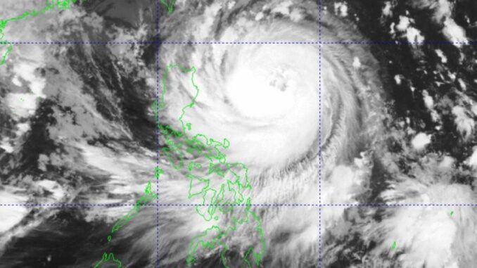
MANILA, Philippines — Severe Tropical Storm “Leon” slightly intensified and is nearing typhoon category, the Philippine Atmospheric Geophysical and Astronomical Services Administration (Pagasa) said on Tuesday.
Signal No. 1 is up over Batanes, Cagayan including Babuyan Islands, Isabela, Quirino, Nueva Vizcaya, Apayao, Kalinga, Abra, Mountain Province, Ifugao, Benguet, Ilocos Norte, Ilocos Sur, La Union, Aurora, the northern portion of Quezon including Polillo Islands (General Nakar, Infanta and Real), Camarines Norte, the eastern portion of Camarines Sur (Tinambac, Siruma, Goa, Lagonoy, San Jose, Garchitorena, Caramoan, Presentacion, Tigaon, Calabanga and Saglay), Catanduanes, the eastern portion of Albay (Rapu-Rapu, Bacacay, City of Tabaco, Tiwi, Malilipot, Malinao, Santo Domingo and Manito), and the northeastern portion of Sorsogon (Prieto Diaz, City of Sorsogon and Gubat).
In Visayas, SIgnal No. 1 was raised over the eastern portion of Northern Samar (San Roque, Pambujan, Catubig, Laoang, Palapag, Gamay, Lapinig, Mapanas and Mondragon) and the northern portion of Eastern Samar (Jipapad, Arteche, Oras and San Policarpo).
Moving west-northwestward at 10 kilometers per hour (kph), Leon was estimated some 645 kilometers east of Tuguegarao City, Cagayan while packing maximum sustained winds of 110kph near the center and gustiness of up to 135kph, the state-run weather agency said.
It said that the highest wind signal which may be hoisted during the occurrence of Leon would be Signal No. 3 or 4, especially in extreme Northern Luzon.
“The hoisting of Signal No. 5 is also not ruled out,” Pagasa administrator Nathaniel Servando told The Manila Times via Viber.
Servando said that although the center of the severe tropical storm would not hit land, its core circulation may directly affect extreme Northern Luzon and the Batanes group of islands.
“Based on current track forecast, Leon will pass through Batanes before moving or making landfall over Taiwan,” he added.
The tropical cyclone is expected to rapidly intensify throughout its passage over the Philippine Sea and may reach typhoon category within the next 12 hours, the state weather bureau said.
There is also an increasing chance that Leon will reach super typhoon category.
Over the next 24 hours, Metro Manila and the rest of the country will be experiencing isolated rain showers or thunderstorms due to localized thunderstorms, the weather agency said.


Be the first to comment