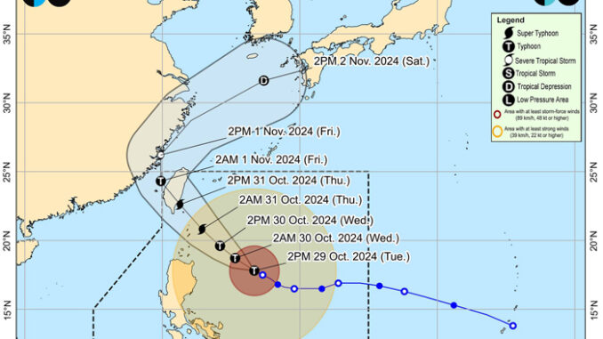
The national government has directed local government units (LGUs) to carry out forced and mandatory evacuations of residents in areas identified as ‘high risk’ ahead of the onslaught of Typhoon ‘Leon.’
Defense Secretary Gilberto Teodoro Jr., who also chairs the National Disaster Risk Reduction and Management Council, issued the order, to which the Department of the Interior and Local Government (DILG) swiftly issued a memorandum directing all LGUs to comply.
“This measure is very crucial to save lives. Being proactive will save lives. It’s better to take action now than to regret later and lose lives,” read the memorandum signed by DILG Officer-in-Charge Undersecretary Lord Villanueva.
The order came as erstwhile tropical cyclone ‘Leon’ intensified into a typhoon over the waters east of Cagayan, the Philippine Atmospheric, Geophysical and Astronomical Services Administration (PAGASA) said Tuesday.
PAGASA reported that ‘Leon’ was blowing winds of 130 kilometers per hour near the center and gustiness of up to 160 km/h.
It was tracked moving west-northwestward at 10 km/h.
Meanwhile, Tropical Cyclone Wind Signal No. 2 was hoisted over four areas in Luzon.
In its 11 a.m. bulletin, PAGASA said TCWS No. 2 is in effect in; Batanes, Babuyan Islands, the eastern portion of mainland Cagayan, and the northeastern portion of Isabela.
TCWS No. 1 remains in effect in 20 provinces, mostly in Northern Luzon, while wind signals in Samar Island were lifted.
PAGASA said Wind Signal Nos. 3 or 4 could be raised over Batanes and Babuyan Islands while hoisting of Signal No. 5 is not ruled out.
As of 10 a.m. Tuesday, ‘Leon’ was monitored 555 kilometers east of Tuguegarao City, Cagayan.
It was expected to hit Batanes, Cagayan, Isabela, Ilocos Norte, and Apayao the hardest, while bringing more heavy to moderate rains to Ilocos Sur, Abra, and Kalinga.
The weather bureau warned that flooding and rain-induced landslides are expected as the possibility of the storm growing to a ‘super typhoon’ level was not discounted.
‘Leon’ will be closest to Batanes on Thursday, where it is expected to make landfall.


Be the first to comment