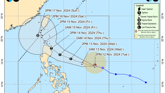
Weather disturbance ‘Ofel’ (Usagi) intensified into a severe tropical storm while moving northwestward at 30 kilometers per hour over east of Virac, Catanduanes, state weather bureau PAGASA said Tuesday.
Based on the 5:00 p.m. weather bulletin, the new cyclone is projected to make its landfall along the east coast of Cagayan or Isabela by Thursday. Both provinces are still reeling from previous consecutive storms that hit the Philippines in less than a month.
“It will then emerge over the Luzon Strait, turn more northwestward on Friday (15 November) while slowing down before behaving erratically during the weekend,” PAGASA said in its advisory.
“Regardless of the position of the landfall point, it must be emphasized that hazards on land and coastal waters may still be experienced in areas outside the landfall point or forecast confidence cone,” it added.
PAGASA said Ofel’s track may still change in the coming days, but it is forecast to steadily intensify and even reach typhoon category by tomorrow. At present, the weather bureau is looking at two scenarios that may emerge based on the storm’s movement.
These include “a west northwestward track with a land crossing that is further south of the present scenario and a recurving track to the right of the present forecast, which will bring ‘Ofel’ mainly offshore of Northern Luzon.”
‘Ofel’ is forecast to steadily intensify in the next three days and reach typhoon category Wednesday evening or Thursday early morning. It may reach its peak intensity prior to landfall. No tropical cyclone wind signal is hoisted yet.
Meanwhile, PAGASA reported that ‘Nika’ (Toraji) weakened into a tropical storm as it left the Philippine Area of Responsibility. It is no longer posing any threat of storm surge in any part of the country, according to the weather bureau.
“’Nika’ will continue moving generally west northwestward to westward over the West Philippine Sea before shifting to a more southwestward movement from Thursday onwards,” PAGASA noted.


Be the first to comment